Leader: Ann
Photos and report: Annette
Total length 8.6km
Total elevation gain: 434m
Time: Four hours including refreshment breaks
Our usual Thursday walk occurred this time on ANZAC Day.
Sixteen walkers enjoyed warm autumn weather, though a bit windy when we passed through exposed places. The walk up through the Rhodes Track had us puffing, with an elevation gain of over 400m within 3.7km. We enjoyed a leisurely lunch below Gibraltar Rock, our highest point. Three of our group climbed to the top of Gibraltar Rock.
It was very pleasant wending our way through the bush on the way down, though we noticed it was very dry. There was only a small flow of water in the stream that we crossed below Anne’s Falls.
Our trek included using the Rhodes, Prendergasts, Kirks and Nelsons Tracks.
Leader and report: William
Photos: William and Anh
Total distance: 15km
Time: Approx three hours including refreshment breaks
In a change from our scheduled Purple Peak walk, it was decided that an alternative walk, starting from the Pioneer Stadium, would be undertaken.
I volunteered to lead a walk in the opposite direction from the usual walk and thought that we could be like Dr Livingstone and find the source of the Heathcote River, using a number of well established pathways that are close to the river.
A bright and cheerful group of 14 arrived at the stadium, not knowing what was involved until they were told at the 9 o’clock start.
From the stadium we walked to the Nor West Arc Cycle and Walkway and ventured north heading to Annex Road near the Hillmorton Hospital. This walkway is a formed trail that uses side roads and runs close to the river and past the Spreydon Reserve, crossing Sparks Road and Lincoln Road. We ventured off the walkway and onto the Christchurch 360 Walkway into the Curletts Wetlands Reserve for the morning tea stop.
After morning tea we crossed Curletts Road and entered the A&P Showgrounds using a track that runs all the way beside the river into Nga Puna Wai Reserve which has the Christchurch City Council sports fields and facilities, including the new indoor sports centre.
We exited the sports grounds and walked some streets in Aidanfield to see some beautiful homes, finally crossing the motorway at Aidanfield Drive where we had lunch just before the start of the Little River Link Walkway.
After lunch we walked along the Little River Link back to Curletts Road and alongside the sports field and showgrounds before joining back up with the Nor West Arc Walkway at Lincoln Road.
Sadly we did not find the source of the river. It was another 600m west of the Aidanfield Bridge and then it goes into the Broken Run Subdivision, crossing Wigram Road before going into the water storage ponds alongside Awatea Road. Maybe another time.
Leaders: Denise and Fran
Photos: Denise
Report: Fran
Distance: approx 11km return
Time: approx four hours
The group of 15 walkers started off from Major Aitken Drive on a day when the forecast was predicting strong winds. All was settled at the beginning of the walk. After walking a steady climb through Coronation Reserve we walked along Huntsbury Ave onto Huntsbury Track where we had morning tea.
As predicted the wind became more obvious as we moved further up towards Scotts Reserve. Unfortunately the wind prevented our group walking over to Tamatea’s Breast. We then walked through Scotts Reserve and onto Mt Vernon where we enjoyed a great view of Christchurch and its surrounds. Two of our walkers did not join us on Mt Vernon. After a short stay on Mt Vernon we returned to Scotts Reserve where we had our lunch.
After lunch the group walked back along Huntsbury Track to Coronation Reserve and our cars. A shorter walk than planned but pleased that we had an enjoyable walk.
Wednesday
From the township we ventured into the nearby Thomas Bush area where the Leith Hill Loop Track is with a total distance of 6.4km with an elevation gain of 352 metres. After this we went to the nearby Kura Tawhiti Conservation Area (Castle Hill boulder area), a place many had seen and driven pass but never stopped. Very interesting seeing the size of the limestone boulders and nature carving.
Leaders: Ann and Eileen
Report and photos: Eileen
Total distance: 8.2km
From the Gondola Base, four walkers decided to get a head start up the steep Bridle Path track before twelve others set off to follow, some walking up the pipeline route with the rest staying on the track. We had morning tea overlooking the harbour in a sheltered spot below the Pioneer Women’s Memorial Shelter, looking down on possibly the last cruise ship of the season.
We followed the Crater Rim track to the Gondola where two of our group left to take the easy and more direct route down – via the gondola! Walking along the ridge there were excellent views over Lyttelton Harbour and north across Pegasus Bay.
Continuing along the Crater Rim we passed the summit of Mt Pleasant and headed down towards our lunch spot at the gun emplacements. By this time, looking southwards, grey storm clouds were gathering and a sudden southerly wind change encouraged us to move on quite quickly, battling strong gusts on the exposed ridge as we descended.
Everyone safely negotiated the steep rocky track down through the Urumau Reserve; we were pleased to be back in Lyttelton before the rain began.
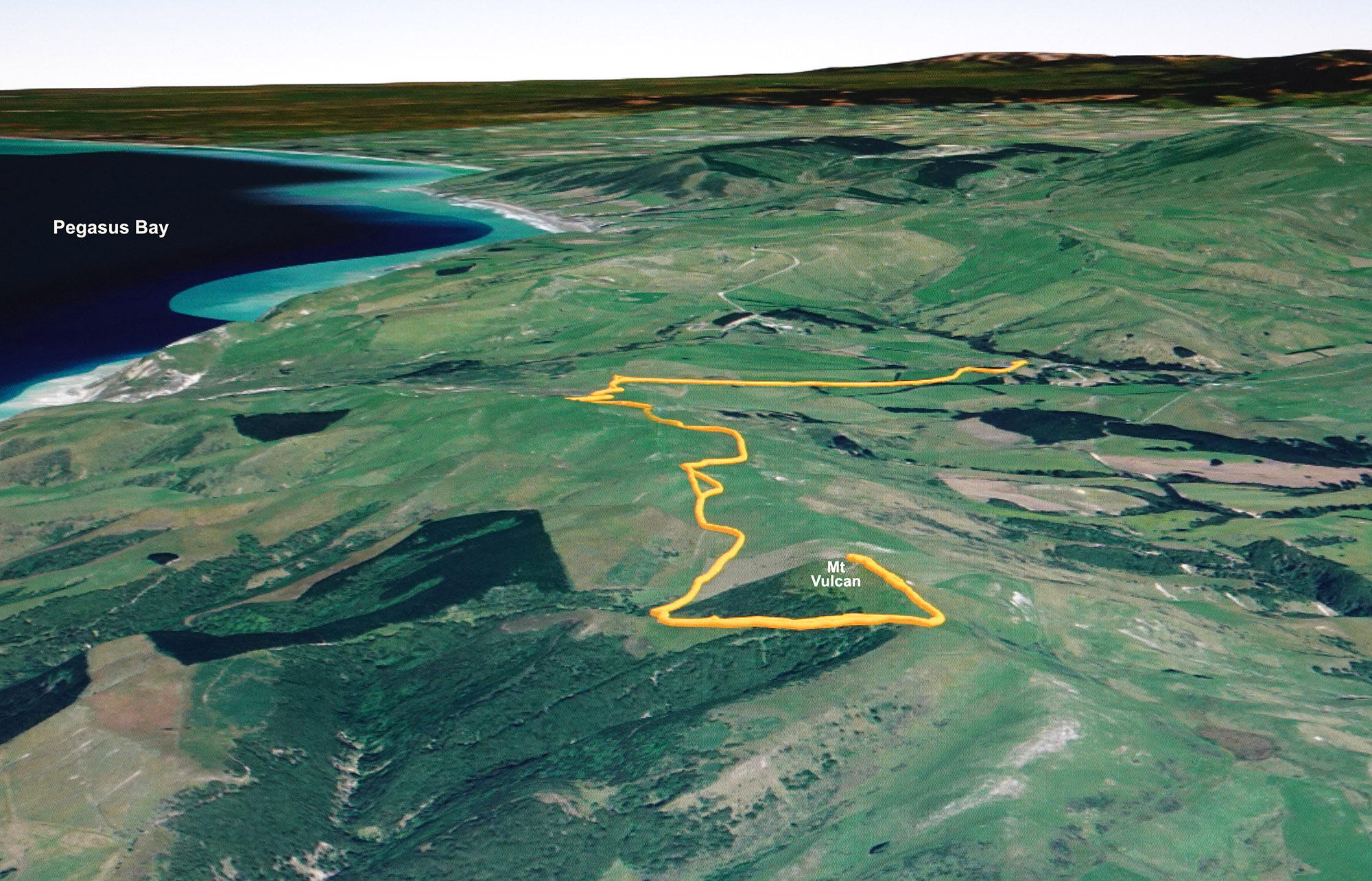
Leaders: Pam and Brian
Photos and report: Annette
Total distance: 11.5km
Total elevation gain: 293m
Time: approx four hours, including two refreshment stops
This walk is within private property and access was kindly given to our group by the farm owner. Public access to this unmarked track is by permission only.
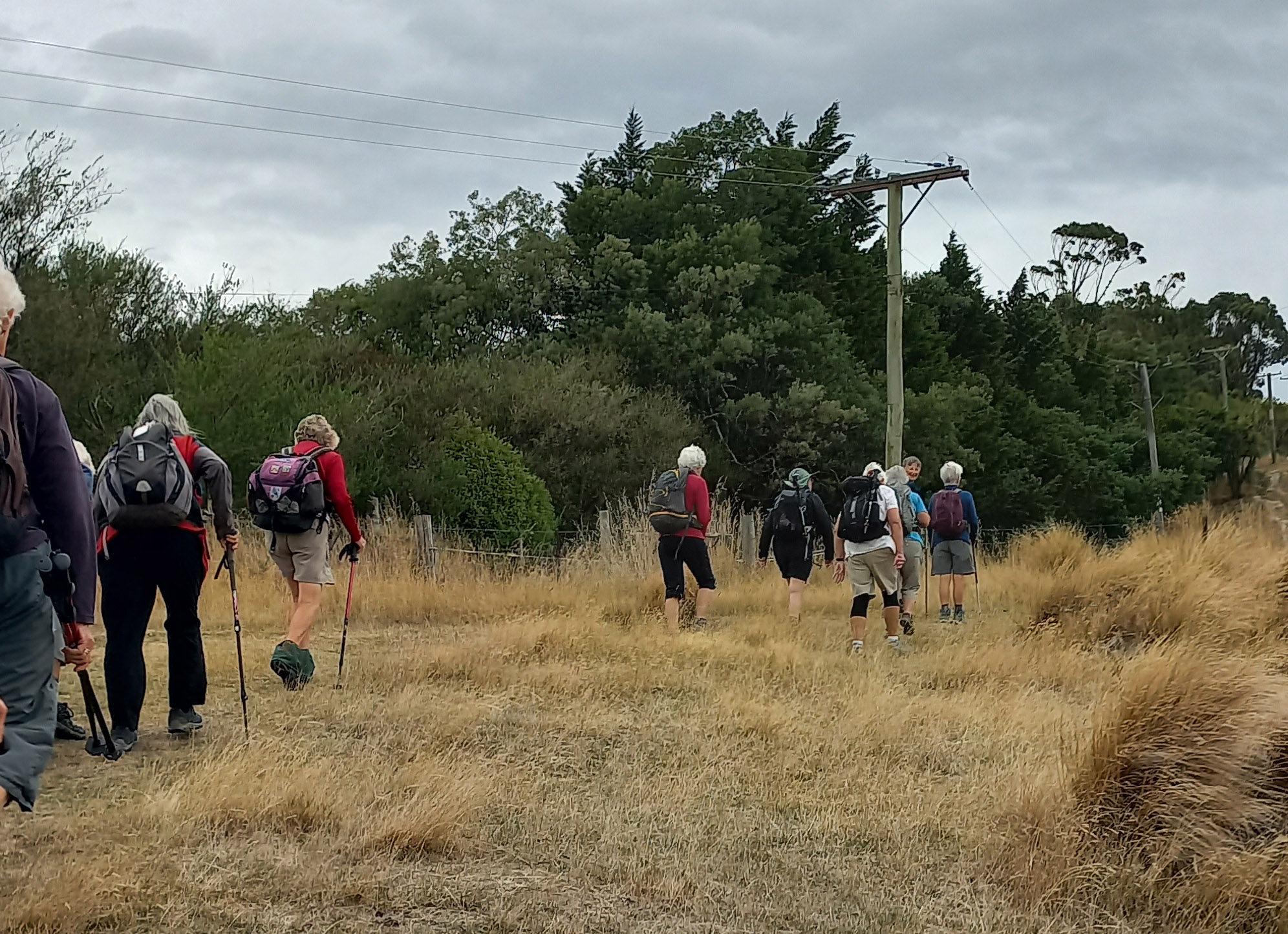
Our leaders once again managed perfect weather for walking on the Mt Vulcan track, with blue skies, a very gentle wind at our highest point and a pleasant temperature of around 20°C. Twenty walkers enjoyed rolling countryside and mountains in the distance, including an occasional cap of autumn snow. We saw cattle in the yards, brought in during the hours before we arrived, and cattle in the paddocks as we passed through. The short steep section up to the summit of Mt Vulcan was worth the effort for the views in every direction.
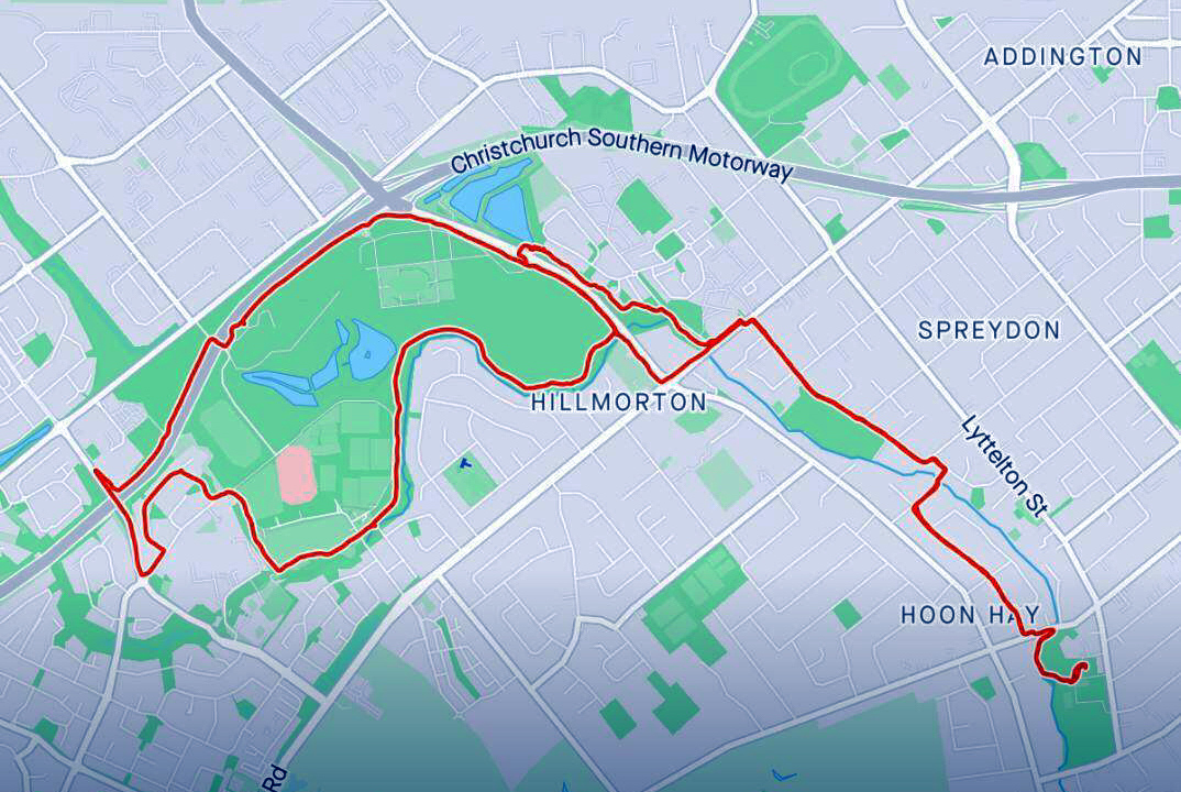
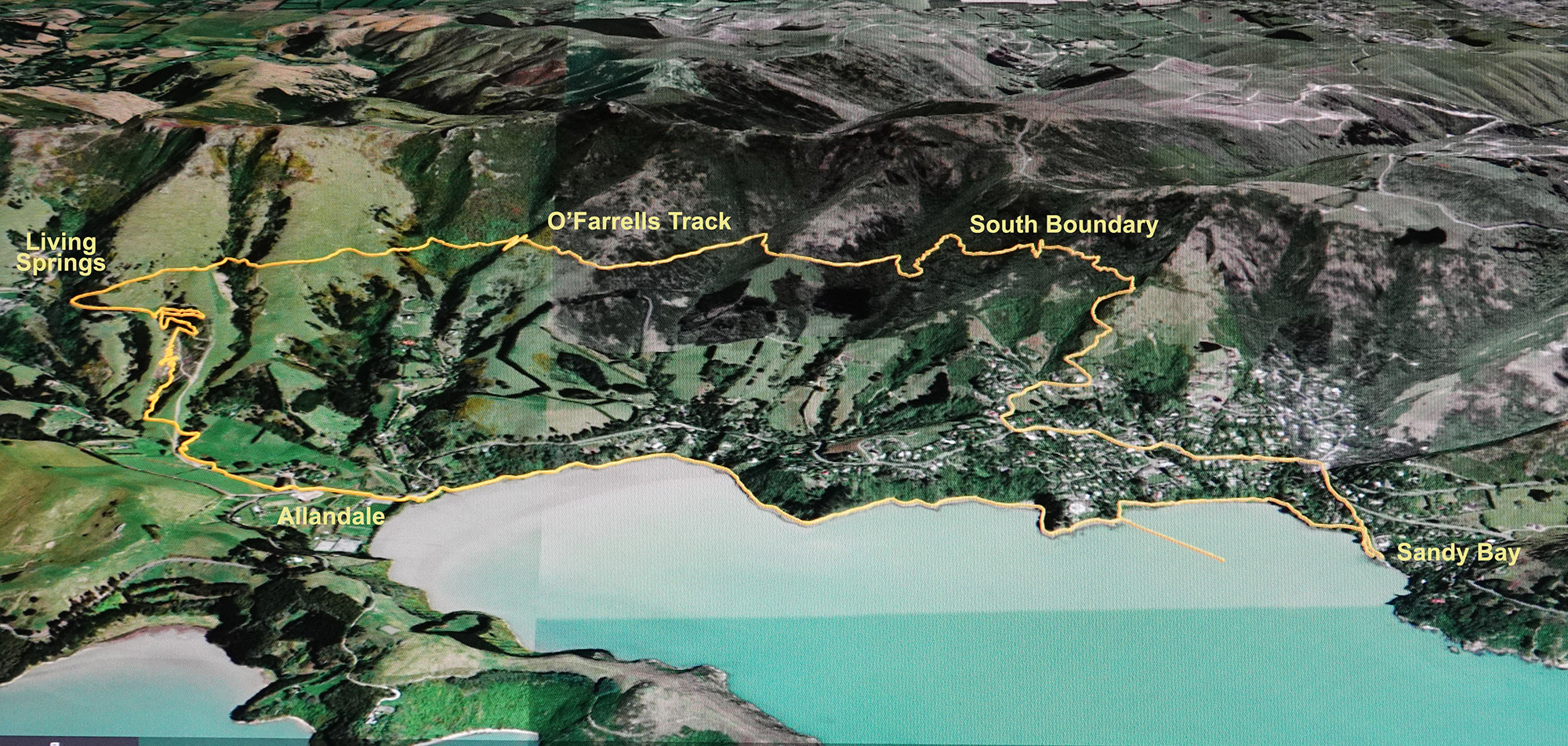
Leader: Pauline
Photos and report: Annette
Total distance: 14.6km
Total elevation gain: 534m
Time: 6 hours including two refreshment stops
GPS-tracked route (click to enlarge)
Our 22 walkers gathered in the Sandy Bay carpark, with cool temperatures at first but it was not long until we were peeling off layers of clothing in the heat. We enjoyed our walk along the foreshore before we walked up through the shade of bush on a bike track to just below Living Springs Event Centre.
On entering the Ohinetahi Reserve we traversed across on the long O’Farrells Track, from where the harbour views were spectacular. Our leader Pauline was already aware that the end section of this track has been closed. So we had to do a detour via the steep Bush Road Track. We thought this steep, bush-clad track might be short but it sure had us puffing in the heat! We then followed the South Boundary Track. Best way down to the township from there is via the Titoki then Ngaio Tracks.
This whole trek took us longer than expected but the expansive views from the high tracks made it very worthwhile!
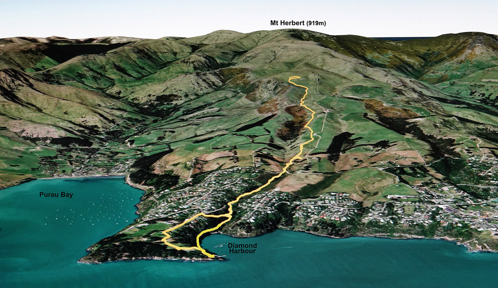
Leader: Pauline
Photos and report: Annette
Total distance: 10km
Height gained: from sea level to 479m
Time: approx 4.5 hours, including two refreshment breaks
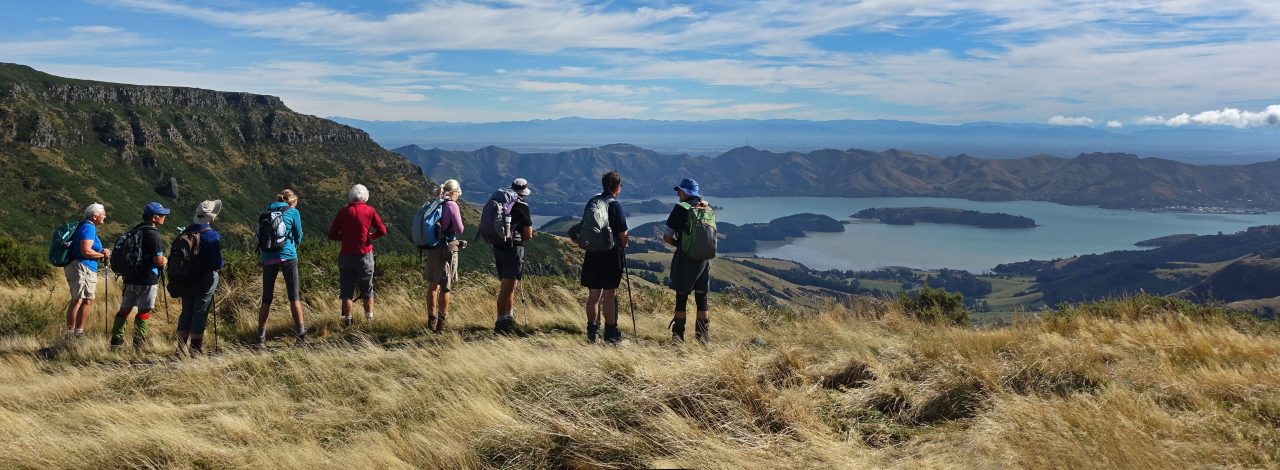
The plan was for our 16 walkers to reach as far as we could on Mt Herbert Walkway before returning to catch the 3pm ferry back to Lyttelton. After a short ferry ride across from Lyttelton, we set off from the Diamond Harbour jetty just after 10am in beautiful walking conditions – a very light breeze and some cloud keeping the temperature pleasant for our climb. As we gained elevation the turquoise waters of the harbour came into view. Apart from some early bush, the route took us through open farmland, returning the same way. Plans are afoot to start earlier if we do this walk again, with the aim of achieving the summit. Many of us have been to Mt Herbert summit multiple times, but not via this route.
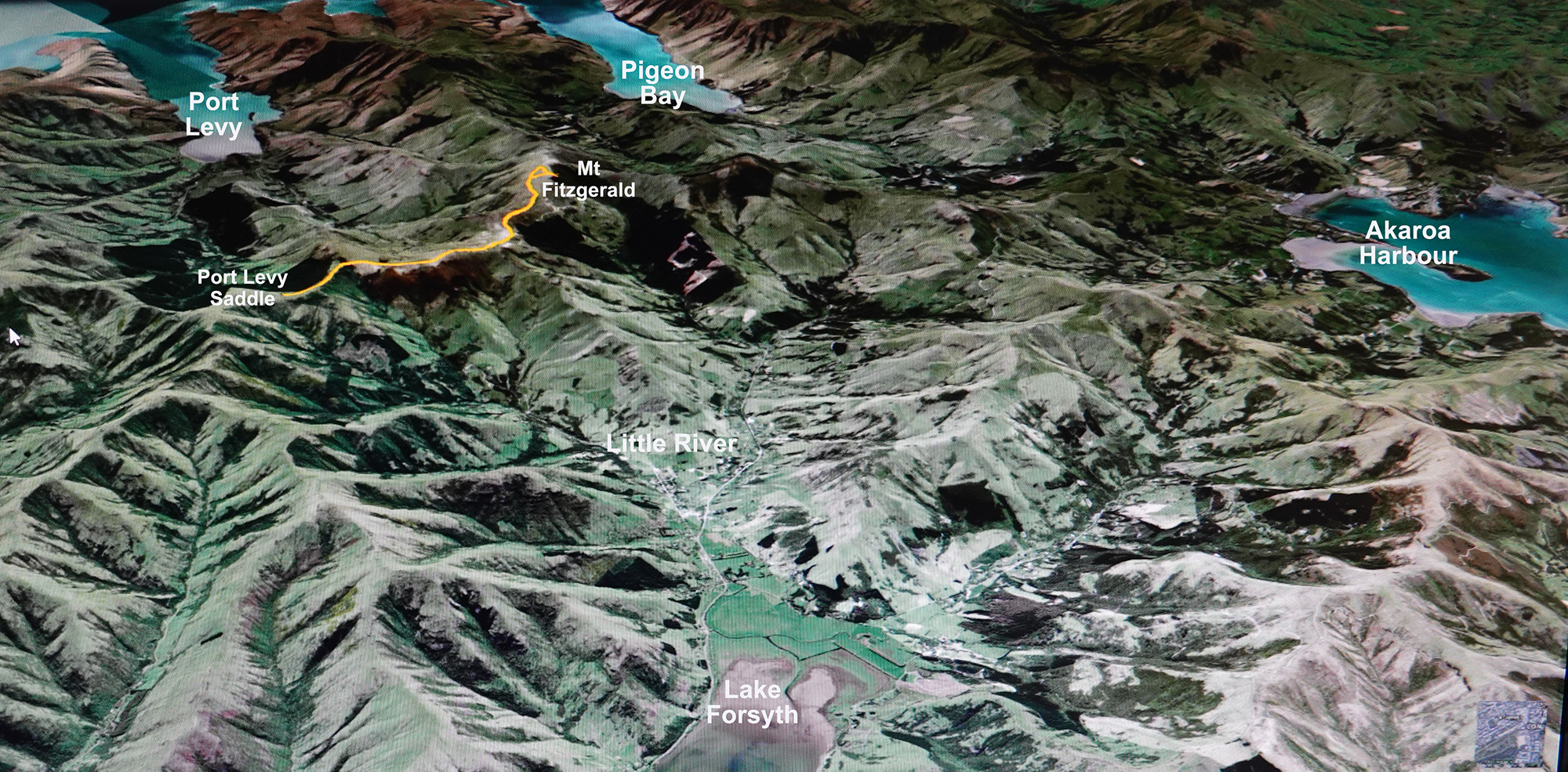
Leaders: Pam and Brian
Photos and report: Annette
Distance out and back: 11.4km
Total elevation gain: 330m
Time: Approx 4.5 hours
Leaving Christchurch, we travelled about an hour via the Akaroa Highway and Western Valley Road to Port Levy Saddle. From inside our cars at the Saddle the weather was not enticing – mist being driven across the sky by a strong easterly wind. But 15 walkers soon got to work. We enjoyed blue skies and wind-blown clouds as we walked a section of Te Ara Pataka/Summit Walkway. Two walkers deviated at Waipuna Saddle on our return, walking down to Rod Donald Hut.
There are links to two videos at the end of the post. One video was taken at the summit, another is of our GPS-tracked route.
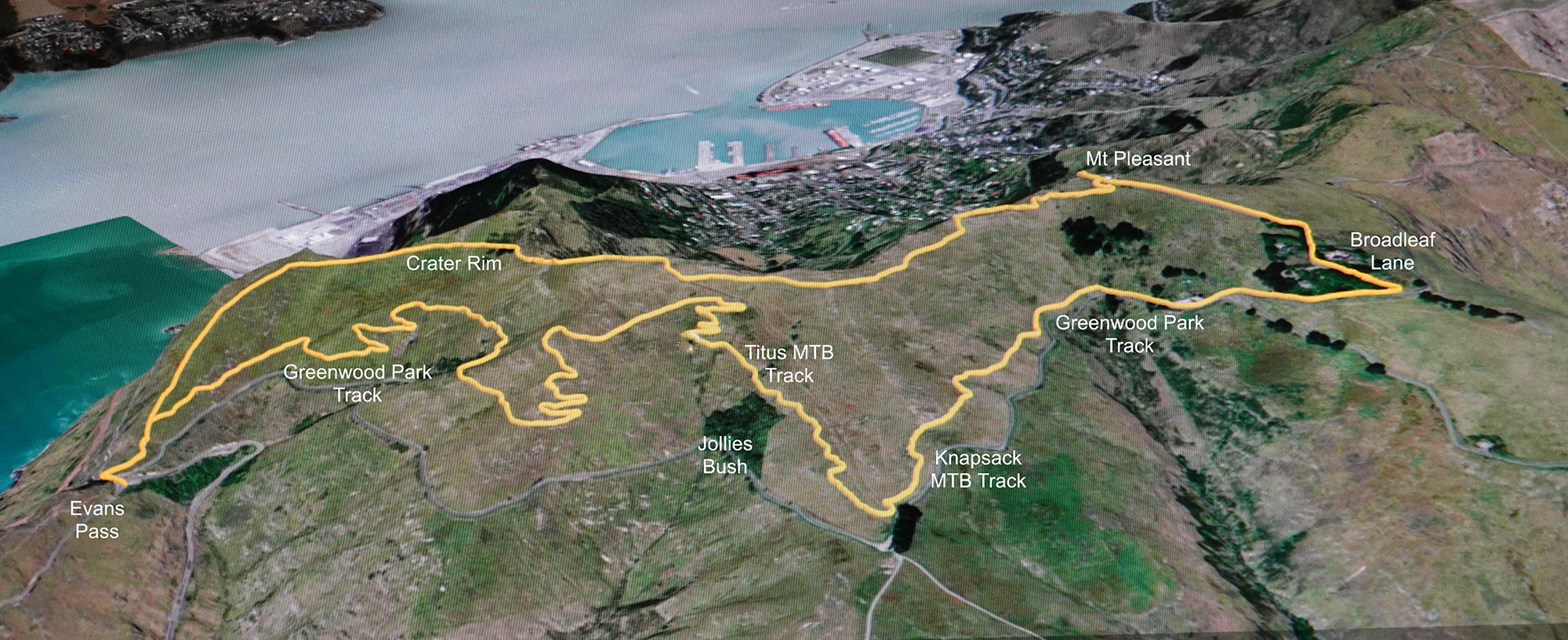
Leaders: Sheila and Ann
Report: Sheila
Photos: Annette
Total distance: 9.7km
Total elevation gained: 390m
Time: Approx four hours, including refreshment breaks
Eleven walkers braved the high temperature to walk from Evan’s Pass to Mt Pleasant, heading uphill on gently sloping but circuitous mountain bike tracks. We stopped for morning tea in a nice shady spot before heading on uphill and then past the top of Jollies Bush. Two walkers headed back after we reached the Summit Road due to the heat. The rest continued on to another shady spot on Broadleaf Lane for lunch and a rest break. We then headed uphill to Mt Pleasant returning to the cars via the Crater Rim track.
Our GPS-tracked route, completed anti-clockwise (click to enlarge)